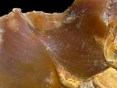
Foto: Jehanne Féblot-Augustins, 2005.
- Les Côtes
Sampled sites:
| Material name: | CC3a |
| Synonyms: | Silex de Crétacé supérieur Centre - Sénonien |
| Material (geologic): | Late Cretaceous (Senonian) flint. |

Foto: Jehanne Féblot-Augustins, 2005. |
Sampled sites:
|
| Mode of occurrence: | Small nodules and fragments of tabular flint. |
| Cortex: | 5 mm thick, worn, rough and pitted, reddish yellow, transition sharp and marked by a thin brown line (iron oxides); pale thin concentric banding immediately below the cortex due to the outward migration of large quantities of sponge spicules. |
| Colour: | Reddish brown (7.5YR 4.5/2). |
| Pattern: | Featureless (rare 5 mm patches of unreplaced matrix, 1 to 2 mm concentrations of skeletal grains and carbonaceous matter). |
| Appearance: | Very homogeneous material with a shiny to medium lustre, subtranslucent, smooth, fine-grained. |
| Structure: | Grains regularly distributed. |
| Texture: | Mudstone, to very locally wackestone. |
| Matrix: | Subtranslucent to milky. |
| Grains: | 5 to 7.5 % (locally 15 %), skeletal grains and carbonaceous matter, pale-coloured or stained by iron oxides, subangular to rounded with high sphericity, regularly distributed and contained between 50 and 125 µ; fuzzy irregularly shaped elements of 250 µ. |
| Grain composition: | Rare very small globose and biserial planktonic foraminifera, benthic foraminifera (Nodosaria sp.), thin-walled sponge spicules, bryozoan fragments (?); abundant carbonaceous elements, frequent iron oxides. |
| Further information: | Click here for the original French description (opens in a new window), or here for more information on the attributes used in the description (use your browser's "BACK"-button to return here). |
| Citing: | Information on citing this page can be found here. |
| Locality: | Andert-et-Condon / Andert - Les Côtes, France, Ain department |
| Synonyms: | Sampling site Bugey 52 after Féblot-Augustins |
| Geographical description: | N/A |
| Geographical co-ordinates: |
east/x 858,4 north/y 2092,2 (Lambert zone II, NTF)
This corresponds roughly with |
| Co-ordinate precision: |
The coordinates given were taken from a large-scale map, and won't be off by more than 50 metres. The latitude/longitude coordinates are a direct transformation of these data on WGS84 and are accurate to the same level, so give or take an arc-second or two. The location can be found on the 1:25 000 topographical map sheet 3231 E of the French Institut Géographique National. |
| Geology: |
According to the geological map, the substrate is of Oligocene age (unit 'g'). The flint istself originates in Late Cretaceous (Senonian) sediments and lies here in a secondary position. Map of all sampled localities of Late Cretaceous flint in the Bugey (PDF, 54 KB, opens in new window). |
| Type of source: | Secondary. |
| Other types of flint: | Apart from the CC3a flint, quite a lot of other Late Cretaceous (Senonian) flints can be found here, CC2, CC3b, CC4a, CC4b as well as Early Cretaceous (Urgonian) material of the Ur-type |
thumb.jpg) Foto: Jehanne Féblot-Augustins, 2005 |
thumb.jpg) Foto: Jehanne Féblot-Augustins, 2005 |
| Last modified on: November 15, 2005 |
Contents primarily by: Jehanne Féblot-Augustins |
Comments to: |