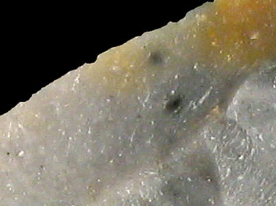
Foto: Jehanne Féblot-Augustins, 2005.
- Villes-En Lachat
Sampled sites:
| Material name: | CE1c |
| Synonyms: | Silex Crétacé supérieur Est - Sénonien (Campanien) |
| Material (geologic): | Campanian (Senonian/Late Cretaceous) flint |

Foto: Jehanne Féblot-Augustins, 2005. |
Sampled sites:
|
| Mode of occurrence: | Ovoid pebbles and cobbles. |
| Cortex: | Rolled neo-cortex, smooth and thin (<1 mm), grey, transition sharp. |
| Colour: | Grey (N5) with indistinct darker grey or light tan patches. |
| Pattern: | Basically featureless, a few specks and spots. |
| Appearance: | Homogeneous material, dull and opaque, moderately smooth and quite dry, medium-grained. |
| Structure: | No particular structure. |
| Texture: | Wackestone. |
| Matrix: | Milky. |
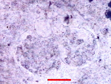
| Grains: | 20 %, pale, micritized, high sphericity, contained between 100 and 500 µ. |
| Grain composition: | Numerous globose planktonic foraminifera (e.g. Hedbergella sp. of 500 µ), whole or fragmented (discrete chambers of 100-120 µ), very rare biserial Heterohelicidae, a Lenticulinea, a few thick-walled monaxon sponge spicules. |
 Globotruncanidae (Hedbergella sp.) in CE1c flint |
||
|
Photo: A. Arnaud Vanneau, (Laboratoire de Géodynamique des Chaînes Alpines, Grenoble) Determination: M. Caron, Université de Fribourg. |
| Further information: | Click here for the original French description (opens in a new window), or here for more information on the attributes used in the description (use your browser's "BACK"-button to return here). |
| Citing: | Information on citing this page can be found here. |
| Locality: | Villes / En Lachat, France, Ain department |
| Synonyms: | Sampling site Bugey 49 after Féblot-Augustins |
| Geographical description: | The source is located in some fields, under a kilometre away in a northwesterly direction from the hamlet/village of Villes, some eight kilometres SW of Bellegarde-sur-Valserine. |
| Geographical co-ordinates: |
east/x 866,3 north/y 2127,5 (Lambert zone II, NTF)
This corresponds roughly with |
| Co-ordinate precision: |
The coordinates given were taken from a large-scale map, and are within approx. 50 metres of the actual spot. The latitude/longitude coordinates are a direct transformation of these data on WGS84 and are accurate to the same level; the 1-second precision is given to prevent any rounding-errors. The location can be found on the 1:25 000 topographical map sheet 3329 W of the French Institut Géographique National. |
| Geology: |
According to the geological map, the substrate belongs to the Early to Middle Miocene (without distinction between Burdigalian and Helvetian), unit m1b-2a. Map of all sampled localities of Late Cretaceous flint in the Bugey (PDF, 54 KB, opens in new window). |
| Type of source: | Secondary. Redeposited Campanian flint from Miocene sediments. |
| Other types of flint: | The flint here constitutes quite a mixed lot, with predominantly Late Cretaceous material like CE1a, CE1b, CE2, CE3, CE4a, CE4b, and CE5, but also Hauterivian (Early Cretaceous) material of the Ht3-type. |
thumb.jpg) Foto: Jehanne Féblot-Augustins, 2005 |
thumb.jpg) Foto: Jehanne Féblot-Augustins, 2005 |
| Last modified on: November 15, 2005 |
Contents primarily by: Jehanne Féblot-Augustins |
Comments to: |