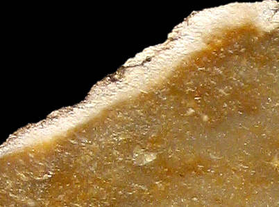
Foto: Jehanne Féblot-Augustins, 2005.
| Material name: | CN1a |
| Synonyms: | Silex Crétacé supérieur Nord - Sénonien (Campanien) |
| Material (geologic): | Campanian (Senonian, Late Cretaceous) flint |

Foto: Jehanne Féblot-Augustins, 2005. |
| Mode of occurrence: | In primary context, continuous beds 7 to 10 cm thick; in secondary context, globular nodules of various sizes (max. 15x10x7 cm). |
| Cortex: | Either fresh, chalky and rough, greyish white, full of sponge spicules, thickness ranging between 2 and 8 mm, transition sharp and highlighted by a recrystallization front; or worn, smooth and thin (1 to 2 mm), typical of a reworked material, or occasionally still slightly chalky and superficially stained brown. |
| Colour: | Yellowish brown hues (10YR 4.5/4), very occasionally verging on greenish hues (2.5Y 5/2). |
| Pattern: | Pale millimetric specks, occasionally strung together (recrystallization haloes around concentrations of elements), thin ochre streaks. |
| Appearance: | Very homogeneous material with a medium lustre, translucent in thin flakes, smooth and fine-grained. |
| Structure: | Slight to more distinctly fluidal arrangement of grains. |
| Texture: | Wackestone. |
| Matrix: | Subtranslucent (cloudy) to translucent, particularly in thin flakes. |
| Grains: | 15 to 20 %, either white or more seldom stained by iron oxides, subangular with high (100 to 400 µ) to low (1000 µ) sphericity, or fuzzy, milky, irregularly shaped, and surrounded by recrystallization haloes. |
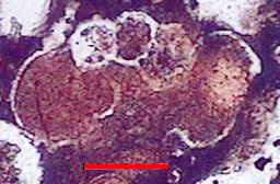
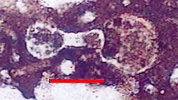
| Grain composition: | Numerous planktonic foraminifera, globose (Hedbergella planispira, Globigerinelloides sp., Archaeoglobigerina cretacea) and biserial (Heterohelicidae), very numerous monaxon or triaxon sponge spicules, both thin- and thick-walled; abundant iron oxides. |
 Globotruncanidae (Archaeoglobigerina cretacea) in CN1a flint |
 Planomalinidae (Globigerinelloides sp.) in CN1a flint |
|
|
Photos: A. Arnaud Vanneau, (Laboratoire de Géodynamique des Chaînes Alpines, Grenoble) Determination: M. Caron, Université de Fribourg. |
| Further information: | Click here for the original French description (opens in a new window), or here for more information on the attributes used in the description (use your browser's "BACK"-button to return here). |
| Citing: | Information on citing this page can be found here. |
| Locality: | Poncin / Breignes - Pierre-Feu 2, France, Ain department |
| Synonyms: | Sampling site Bugey 34 after Féblot-Augustins |
| Geographical description: | The source is located near a narrow road/path on a slight rise between the hamlets of Chenavel and Breignes, a bit over half a kilometre to the west of the latter, and somewhat more than 2 kilometres SSE of Poncin. |
| Geographical co-ordinates: |
east/x 838.2 north/y 2122.9 (Lambert zone II, NTF)
This corresponds with |
| Co-ordinate precision: |
The Lambert-coordinates given were read from a detailed topographical map, and are within 50 metres of the precise location. The latitude/longitude coordinates are a direct transformation of these data on WGS84 and have the same accuracy. They are given to the apparent high accuracy to prevent the introduction of a rounding-error. The location can be found on the 1:25 000 topographical map sheet 3230 W of the French Institut Géographique National. |
| Geology: |
The embedding materials are, according to the geological map, Late Miocene (Tortonian) continental sediments, belonging to the stratigraphic unit m2bC. The reworked flints themselves originate from Late Cretaceous (Campanian) limestones. Map of all sampled localities of Late Cretaceous flint in the Bugey (PDF, 54 KB, opens in new window). |
| Type of source: | Secondary. Redeposited Campanian flint from Miocene sediments. |
| Other types of flint: | Apart from the CN1a-type, other Late Cretaceous flints of the types CN2a and CN8c can be found here, as well as the Middle Jurassic Bt material and Early Cretaceous Ht1 flint. |
thumb.jpg) Foto: Jehanne Féblot-Augustins, 2005 |
| Locality: | Poncin / Chenavel - Chatanay, France, Ain department |
| Synonyms: | Sampling site Bugey 48 after Féblot-Augustins |
| Geographical description: | The sampling-site is located directly adjacent to a narrow road, a bit over a kilometre to the (S)SW of Poncin. |
| Geographical co-ordinates: |
east/x 836,7 to 836,8 north/y 2124 to 2124,2 (Lambert zone II, NTF)
This corresponds roughly with |
| Co-ordinate precision: |
As the site is a few hectares in size, precision is not of the highest importance, but the coordinates lie well within the area. The geographical coordinates point to a spot near the centre of the site. The location can be found on the 1:25 000 topographical map sheet 3230 W of the French Institut Géographique National. |
| Geology: |
The material from this site can be classified as surface-collected flint or in eroded gulleys, Chenavel sector, clays-with-flint of various geological origins (Early and Late Cretaceous); Unit S (Rs). Map of all sampled localities of Late Cretaceous flint in the Bugey (PDF, 54 KB, opens in new window). |
| Type of source: | Secondary. |
| Other types of flint: | Besides the Campanian CN1a material, several types of Late Cretaceous material can be found here (CN2a, CN2c, CN4a, CN4b, and CN6), as well as Early Cretaceous Ht3 flint. |
thumb.jpg) Foto: Jehanne Féblot-Augustins, 2005 |
thumb.jpg) Foto: Jehanne Féblot-Augustins, 2005 |
|
thumb.jpg) Foto: Jehanne Féblot-Augustins, 2005 |
thumb.jpg) Foto: Jehanne Féblot-Augustins, 2005 |
| Locality: | Leyssard / Solomiat - Le Petit Bois, France, Ain department |
| Synonyms: | Sampling site Bugey 54 after Féblot-Augustins |
| Geographical description: | The source is located just next to the small road which connects the hamlet of Solomiat with the D 979, the main road in the northern part of the Bugey, linking Bourg-en-Bresse with Bellegarde-sur-Valserine. Solomiat lies approx. 10 kilometres as the crow flies WNW of Nantua, near, but high above, the left bank of the river Ain. |
| Geographical co-ordinates: |
east/x 842.7 north/y 2135.3 (Lambert zone II, NTF)
This corresponds roughly with |
| Co-ordinate precision: |
The Lambert easting and northing were read from a detailed topographical map, and accurate within 50 to 100 metres. The Latitude/Longitude coordinates are a direct transformation of the Lambert values, and therefore within the same margin of error. The location can be found on the 1:25 000 topographical map sheet 3229 W of the French Institut Géographique National. |
| Geology: |
According to the geological map, the substrate belongs to unit C6, Late Cretaceous/Senonian sediments. Map of all sampled localities of Late Cretaceous flint in the Bugey (PDF, 54 KB, opens in new window). |
| Type of source: | Primary. |
| Other types of flint: | Being a primary source, this location only yields the CN1a type, but the adjacent site 59 (Solomiat-Le Petit Bois (secondary)) also contains some other types of flint. |
thumb.jpg) Foto: Jehanne Féblot-Augustins, 2005 |
| Locality: | Leyssard / Solomiat - Crossroads, France, Ain department |
| Synonyms: | Sampling site Bugey 55 after Féblot-Augustins |
| Geographical description: | The exposure where this sample was collected lies directly along the D 979, the main road in the northern part of the Bugey, linking Bourg-en-Bresse with Bellegarde-sur-Valserine. It is located in a wide left-curve some four kilometres after the road crossed the river at Serrières-sur-Ain in the direction of Bellegarde-sur-Valserine. |
| Geographical co-ordinates: |
east/x 842.5 north/y 2134.6 (Lambert zone II, NTF)
This corresponds with |
| Co-ordinate precision: |
The coordinates given were taken from a large-scale map, and are within approx. 50 metres of the actual spot. The latitude/longitude coordinates are a direct transformation of these data on WGS84 and are accurate to the same level. The location can be found on the 1:25 000 topographical map sheet 3229 W of the French Institut Géographique National. |
| Geology: |
According to the geological map, the substrate belongs to unit C6, Late Cretaceous/Senonian sediments. Map of all sampled localities of Late Cretaceous flint in the Bugey (PDF, 54 KB, opens in new window). |
| Type of source: | Primary. |
| Other types of flint: | All flint from this exposure belongs to the CN1a type. |
thumb.jpg) Foto: Jehanne Féblot-Augustins, 2005 |
| Locality: | Leyssard / Le Devin, France, Ain department |
| Synonyms: | Sampling site Bugey 56 after Féblot-Augustins |
| Geographical description: | The sampling site is located just above some hairpin-bends in the narrow road which connects the village of Leyssard with the main road D 979. Nearby there also is a path which goes from the mentioned hairpin-bends in the direction of Sonthonnax-le-Vignoble to the west. |
| Geographical co-ordinates: |
east/x 842.37 north/y 2134 (Lambert zone II, NTF)
This corresponds roughly with |
| Co-ordinate precision: |
As usual, the French Lambert-values were taken off a large-scale topographical map and the geographical coordinates were calculated directly by transforming those values on WGS84. The precision of both are within 50 metres. The location can be found on the 1:25 000 topographical map sheet 3229 W of the French Institut Géographique National. |
| Geology: |
According to the geological map, the substrate consists of clays-with-flints (Rs), which are the residues of dissolved/decalcified Late Cretaceous formations (C6). Map of all sampled localities of Late Cretaceous flint in the Bugey (PDF, 54 KB, opens in new window). |
| Type of source: | Secondary. |
| Other types of flint: | The residual loams on this location contain also CN1b and CN2b flint. |
thumb.jpg) Foto: Jehanne Féblot-Augustins, 2005 |
| Locality: | Leyssard / Solomiat - Le Petit Bois, France, Ain department |
| Synonyms: | Sampling site Bugey 59 after Féblot-Augustins |
| Geographical description: | The source is located just east of the small road which connects the hamlet of Solomiat with the D 979, the main road in the northern part of the Bugey, linking Bourg-en-Bresse with Bellegarde-sur-Valserine. Solomiat lies approx. 10 kilometres as the crow flies WNW of Nantua, on a terrace on left bank of the river Ain, some 360 metres above the bottom of the narrow valley. |
| Geographical co-ordinates: |
east/x 842.7 north/y 2135.3 (Lambert zone II, NTF)
This corresponds with |
| Co-ordinate precision: |
As usual, the French Lambert-values were taken off a large-scale topographical map and the geographical coordinates were calculated directly by transforming those values on WGS84. The precision of both are within approx. 50 metres. The location can be found on the 1:25 000 topographical map sheet 3229 W of the French Institut Géographique National. |
| Geology: |
The flint is to be found in residual loams left after the decalcification of Late Cretaceous (Senonian) limestones, unit Rs on the geological map. Map of all sampled localities of Late Cretaceous flint in the Bugey (PDF, 54 KB, opens in new window). |
| Type of source: | Secondary. |
| Other types of flint: | Apart from the CN1a-type, also two other flints of Senonian age can be found here, namely CN2b and CN4c. |
thumb.jpg) Foto: Jehanne Féblot-Augustins, 2005 |
| Locality: | Jujurieux / Chenavel - Château 2, France, Ain department |
| Synonyms: | Sampling site Bugey 66 after Féblot-Augustins |
| Geographical description: | The material was collected along the GR 59 long-distance footpath near the castle of Chenavel, which lies between the hamlet of Chenavel and the N 84 road, overlooking the river Ain, between Poncin and Pont-d'Ain. |
| Geographical co-ordinates: |
east/x 835.95 north/y 2123.1 (Lambert zone II, NTF)
This corresponds roughly with |
| Co-ordinate precision: |
The French coordinates of the national Lambert-grid were read from an detailed topographical map. We calculated the geographical coordinates by transforming those values on the WGS84 ellipsoid. The location can be found on the 1:25 000 topographical map sheet 3130 E of the French Institut Géographique National. |
| Geology: |
The flint here occurs in clays-with-flints of various origins (Early and Late Cretacous), although the silex is clearly of Late Cretaceous (Senonian) age. Map of all sampled localities of Late Cretaceous flint in the Bugey (PDF, 54 KB, opens in new window). |
| Type of source: | Secondary. |
| Other types of flint: | Two other Senonian flints might be found here: CN8a and CN8b. |
thumb.jpg) Foto: Jehanne Féblot-Augustins, 2005 |
thumb.jpg) Foto: Jehanne Féblot-Augustins, 2005 |
| Locality: | Jujurieux / Chenavel - Les Brovières 3, France, Ain department |
| Synonyms: | Sampling site Bugey 68 after Féblot-Augustins |
| Geographical description: | The sampling site is one of a small cluster which lies approx. 150 metres above the bottom of the valley in a bend of the river Ain, about a kilometre and a half southwest of Poncin, and a kilometre to the north of Chenavel. |
| Geographical co-ordinates: |
east/x 836.3-836.4 north/y 2123.8-2124 (Lambert zone II, NTF)
This corresponds with |
| Co-ordinate precision: |
As you can see from the coordinates, the site is a couple of hectares in size, so precision is not of that much importance. The French coordinates were taken from a large-scale map, the geographic coordinates point to a spot in the approximate centre of the area. The location can be found on the 1:25 000 topographical map sheet 3130 E of the French Institut Géographique National. |
| Geology: |
The embedding material of these flints consists of residual loams (clays-with-flints), which were left behind as teh original Late Cretaceous limestone was eroded. Map of all sampled localities of Late Cretaceous flint in the Bugey (PDF, 54 KB, opens in new window). |
| Type of source: | Secondary. |
| Other types of flint: | Although it is a secondary source, all material her belongs to the CN1a-type, but there are several other sites nearby where other Late Cretaceous flints can be found. |
thumb.jpg) Foto: Jehanne Féblot-Augustins, 2005 |
| Locality: | Poncin / Breignes - Pierre-Feu 1, France, Ain department |
| Synonyms: | Sampling site Bugey 70 after Féblot-Augustins |
| Geographical description: | The sample was collected between the hamlets of Cheneval and Breignes, a hunderd metres to the west of sampling site 34, Poncin / Breignes - Pierre-Feu 2. |
| Geographical co-ordinates: |
east/x 838.1 north/y 2122.9 (Lambert zone II, NTF)
This corresponds roughly with |
| Co-ordinate precision: |
The coordinates are to the nearest 50 metres on a detailed topographical map. The Lat/Long are a direct transformation of these on WGS84, within the same limits of accuracy. The location can be found on the 1:25 000 topographical map sheet 3230 W of the French Institut Géographique National. |
| Geology: |
According to the geological map, the substrate belongs to unit m2bC-Rs : Late continental Miocene (Tortonian) and possibly clays-with-flint of Late Cretaceous origin. Map of all sampled localities of Late Cretaceous flint in the Bugey (PDF, 54 KB, opens in new window). |
| Type of source: | Secondary. |
| Other types of flint: | The Late Cretaceous CN2a and CN4c flints occur here too. |
thumb.jpg) Foto: Jehanne Féblot-Augustins, 2005 |
thumb.jpg) Foto: Jehanne Féblot-Augustins, 2005 |
| Last modified on: November 15, 2005 |
Contents primarily by: Jehanne Féblot-Augustins |
Comments to: |